Geospatial Surveying in Norfolk
Accurate Geospatial Surveying for Reliable Data
Get a Free Quote From Us Today!
We aim to get back to you in 24 hours.
At Geospatial Surveying, we provide specialist spatial data acquisition and analytical mapping services in Norfolk NR and across the UK. Our service focuses on the systematic capture and management of geographic information to ensure project designs are based on absolute physical reality.
By delivering professional technical oversight, Geospatial Surveying helps project teams mitigate structural risks and streamline the transition from physical sites to intelligent digital twins.
When Should You Use Geospatial Surveying for Your Project in Norfolk?
You should engage geospatial surveying in Norfolk during the feasibility or pre-design phase to ensure your architectural plans are built on a solid foundation of fact.
Getting this data early identifies significant engineering bottlenecks, such as structural deflections or boundary encroachments, which prevents the need for expensive redesigns discovered late in the construction cycle. It is also essential to use these services during the operational phase to manage asset lifecycles.
How Much Does Geospatial Surveying Cost in Norfolk?
The cost of geospatial surveying in Norfolk ranges from £1,000 to over £15,000 per project, depending on the site area, the sensor technology utilised, and the required Level of Detail (LOD).
Costs are primarily influenced by the complexity of the data processing needed for BIM or GIS integration, the density of feature mapping requested, the requirement for specialised coordinate control networks, and site accessibility constraints.
Contact Geospatial Surveying to get customised prices for getting surveying at your property.
Capture Accurate Spatial Data Now
What Services Are Included in Geospatial Surveying in Norfolk?
Every geospatial surveying commission in Norfolk delivers a specific sequence of technical outputs tailored to support the design and construction lifecycle:
- Topographical Site Mapping – Recording ground levels and surface features to inform civil design and earthworks volumes.
- Laser Scanning and LiDAR – Capturing high-density 3D point clouds to create accurate digital representations of complex structures.
- GIS Database Management – Structuring spatial data into relational systems that support high-level urban planning and asset maintenance.
- BIM Model Integration – Developing parametric 3D models that facilitate seamless coordination between different engineering disciplines.
- Subsurface Utility Mapping – Identifying the location of buried services to prevent hazardous utility strikes during excavation work.
Where is Geospatial Surveying Used Across Projects in Norfolk?
We deploy geospatial surveying in Norfolk across a diverse range of complex site environments where geometric precision is essential for operational success:
- Highways and Infrastructure – Ensuring vertical and horizontal alignment is safety-critical for road bridge sections, and drainage falls.
- Brownfield Regeneration – Mapping existing ruins and subsurface indicators to manage environmental risk during site clearance.
- Commercial Site Planning – Verifying land suitability and spatial constraints for new large-scale retail or industrial footprints.
- Public Sector Works – Delivering accurate digital twins for the maintenance of public parks, schools, and civic infrastructure.
- Renewable Energy Sites – Mapping terrain profiles for wind turbine placement or solar array alignment to maximise efficiency.
How Does the Geospatial Surveying Process Work in Norfolk?
The rigorous methodology followed for geospatial surveying in Norfolk begins with a technical site reconnaissance to establish the primary control network and data capture parameters. We move to the active data acquisition phase, where our surveyors record coordinates using high-frequency laser and satellite measurements.
This information is then processed using advanced software to filter noise and align measurements with the National Grid. This structured workflow results in a verified digital dataset, which acts as the definitive spatial guide for all engineers and site contractors.
How Quickly Can Geospatial Surveying Be Completed in Norfolk?
Most standard geospatial surveying tasks in Norfolk are completed within three to ten working days, depending on the scale of the landscape and the complexity of the data processing. We understand that maintaining project momentum is critical, so we prioritise efficient data capture and rapid turnaround of digital drawings.
For large-scale infrastructure projects, we coordinate a phased delivery of data, allowing your design team to begin work on priority areas. This responsive service ensures that statutory compliance does not cause bottlenecks, allowing your build programme to remain on schedule.
Which Industries and Projects Benefit From Geospatial Surveying in Norfolk?
Numerous professional sectors benefit from the precision mapping delivered by geospatial surveying in Norfolk. Architects and designers require accurate terrain data to inform creative concepts and prevent structural design clashes, while civil engineers use verified levels to calculate earthworks volumes.
Property developers and legal teams also rely on this spatial data to manage the subdivision of land and the placement of new infrastructure, ensuring projects remain compliant and financially viable.
What Technologies and Data Outputs Are Used in Geospatial Surveying in Norfolk?
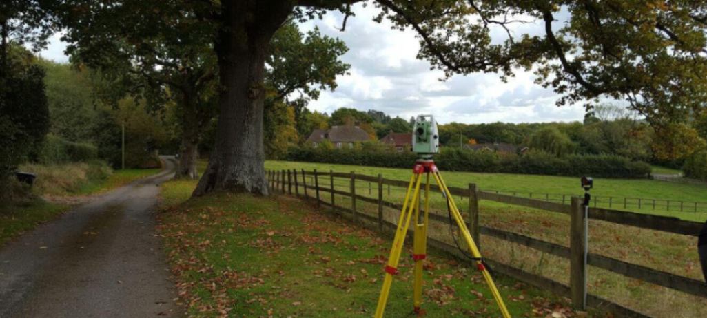
Our technicians at geospatial surveying in Norfolk utilise a suite of advanced geomatic instruments to deliver high-fidelity spatial models:
- GNSS Positioning Systems – Utilising satellite constellations to establish absolute global coordinates for site-wide consistency and accuracy.
- Terrestrial Laser Scanners – Emitting millions of laser pulses per second to record the intricate geometry of built environments.
- GIS Analytical Software – Processing geographic data to identify patterns and inform strategic infrastructure decisions.
- Mobile Mapping Units – Capturing high-resolution spatial data at speed for large-scale highway and rail network surveys.
- UAV Photogrammetry – Deploying drones to capture high-altitude imagery for volumetric analysis and terrain modelling.
Why Should You Choose Professional Geospatial Surveying Services in Norfolk?
Choosing specialist experts for geospatial surveying in Norfolk provides the independent technical verification needed to protect your project from costly design errors. We provide an unbiased audit of site geometry, identifying subtle structural leans or level deviations that internal teams might overlook.
Our professional oversight ensures that the instrumentation used is regularly certified, preventing the cumulative errors that lead to construction failure. Investing in an expert survey optimises the build cycle, providing the technical assurance needed to construct complex infrastructure safely and legally.
What Accuracy Standards and Regulations Apply to Geospatial Surveying in Norfolk?
Strict adherence to RICS professional standards is how geospatial surveying in Norfolk ensures technical consistency and data reliability across the UK. These guidelines define the mandatory tolerances and reporting levels required for measured surveys of land and buildings to ensure public safety and structural performance.
Our processes are also aligned with BS 11000 collaborative standards, ensuring data is structured for seamless BIM integration. Following these benchmarks guarantees a defensible data set that protects the client from spatial errors and potential planning refusals.
Contact Geospatial Surveying for a consultation to get geospatial surveying tailored to your organisation’s risks and responsibilities.
Get a Geospatial Survey Quote Today
What People are Saying About Us
★★★★★
"Geospatial surveying delivered accurate mapping data that supported our planning work perfectly."
Leo Green
East of England
★★★★★
"Great service with clear results and a smooth process throughout."
Evie Hughes
East of England
★★★★★
"Reliable and precise data capture that helped move our project forward."
Max Ward
East of England
★★★★★
"Professional team with excellent attention to detail."
Ruby Hill
East of England
Our Locations
Looking for our services in another area in Norfolk? We are proud to work nationally across the UK, allowing us to ensure we can provide our specialist Geospatial Surveying services to you.
For a full list of locations we cover in Norfolk, see below.